| Santorini Itineraries | Itinerary Fira-Oia | Itinerary Fira-Akrotiri | Itinerary Fira-Pyrgos | Itinerary Caldera | Tours on the island | ||||||||||||||||||||||||||
| Santorini Sailing Cruises | Santorini Volcano Tour | Cruise Ship Tours | ||||||||||||||||||||||||||
√ Excursions in Santorini: the Caldera tour |
||||||||||||||||||||||||||
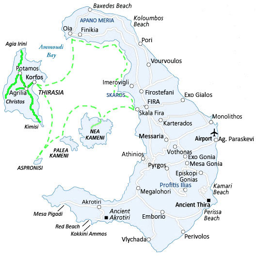 |
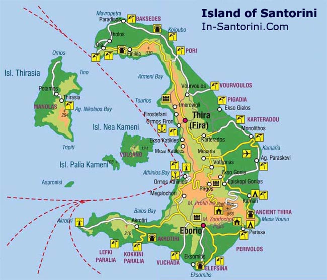
Part of this intinerary will be made on a kayak. Get information about departure time schedule and buy tickets in one of the agencies of the island. Generally there are two departures a day. One in the morning (it's the longest tour) and one in the afternoon. Firà-Mesa Ghialòs: this is the pictoresque and historic street descending down the steep slopes to the Old Harbour of Santorini (you can get there also by cable car). It's also amazing going down or up the slope on the back of donkeys. These ready and willing animals will descend 587 large steps, along the Ghialoòs street, towards the port where your kayak is ready to depart. This small harbor and its bay offer the possibility to take a quick swim (if the sea and the wind are calm). Looking northwards, the bay displays its characteristic yellowish rocks and caves which structure is due to the sea erosion. Once departed, notice the amazing face of the Caldera behind you and its white hat, Firà, that dominates you; notice the sides of the island with its spectacular cave of and its arms that seem to hug you. After just 5 minutes sailing the sea has already reached a depth of 985 ft (it will be even deeper) |
The Volcano - Nea Kameni: Once reached almost the centre of the Caldera, your kayak will pass to the right of the first big rock formed by lava: Nea Kameni. Its aspect is almost primordial, a raven-black material ... magma coming out of the Volcano and suddenly cooled off and solidified. From Vlcano, your next stop is Thirasia, the detached island of Caldera. During the journey you can easily notice the two different islands (Palea e Nea Kameni) forming the Volcano. Once visited Thirasia you'll cross the strait between Thirasia and Apano Merià with a stop in one of the two bays: Ammoudi or Armeni. Those who choose the "Big Boat Trip", besides the Volcano, will also enjoy a walking tour of the pictoresque island of Thirasia and the enchanting sunset in Oia. Thirasia: Thirasia is the second largest island of the Caldera, less developed and with only 245 inhabitants, mostly fishermen and farmers. The main town is indeed Thirasia and you need to climb 145 steps to reach it. |
|
about us | site map | advertising | contacts | disclaimer | links |